Perspective
The coastal disaster research laboratory researches ocean waves, storm surges, and tsunami disasters and their prevention and reduction for human safety in coastal zones. Japan's coastline is roughly 36,000 kilometers long, and the coastal areas are approximately 10 % of the total land area of Japan. Therefore, it is important to learn about, understand, and reduce coastal disasters in Japan.
The following research projects are currently active in our laboratory.
Major Projects
Climate Change Projection and Impact Assessment on Coastal Zones
The influence of global climate change due to greenhouse effects on the earth's environment must be considered in impact assessment, mitigation, and adaptation strategies for our society's future. Coastal areas are especially vulnerable to changes in wave activity and extreme weather events, whether in terms of loss of human life and property or terms of erosion of coastlines and coastal structures.
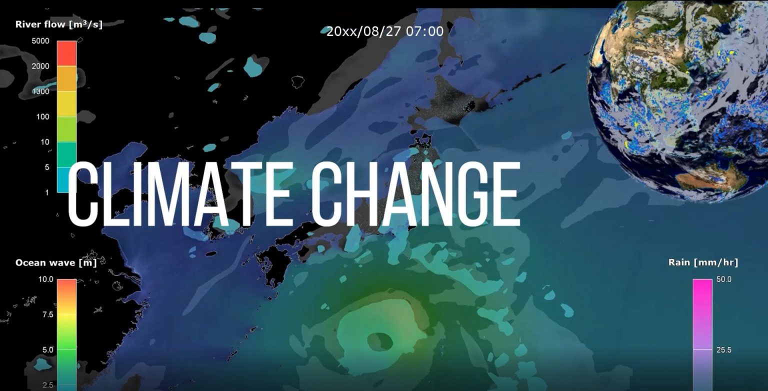
Projection of Future Typhoons/Hurricanes and Storm Surge Change
Global warming influences extreme weather phenomena such as typhoons and hurricanes. The ocean surface momentum transferred from wind to ocean is proportional to the square of wind speed. Therefore, stronger tropical cyclones will cause unexpectedly high waves and storm surges, which are expected to occur by the end of this century. Our research group predicts future changes in the long-term characteristics of typhoons, storm waves, and storm surges under the climate change environment for future coastal environments.
Reference
- Mori, S., T. Shimura, T. Miyashita, A. Webb, N. Mori (2022) Future changes in tropical cyclone intensity and extreme storm surge based on a maximum potential model for East Asia, Coastal Engineering Journal, Taylor & Francis, Vol.84, Issue 4, pp.630-647.
- Ishii, M., N. Mori (2020) d4PDF: large-ensemble and high-resolution climate simulations for global warming risk assessment (review), Progress in Earth and Planetary Science, 7, Article number 58.
https://doi.org/10.1186/s40645-020-00367-7 - Mizuta, R. et al. (2017) Over 5000 years of ensemble future climate simulations by 60 km global and 20 km regional atmospheric models, The Bulletin of the American Meteorological Society (BAMS), July, pp.1383-1398. doi: 10.1175/BAMS-D-16-0099.1
- Mori, N. and T. Takemi (2016) Impact assessment of coastal hazards due to future changes of tropical cyclones in the North Pacific Ocean, Weather and Climate Extremes (review paper), Vol.11, pp.53-69. doi: 10.1016/j.wace.2015.09.002
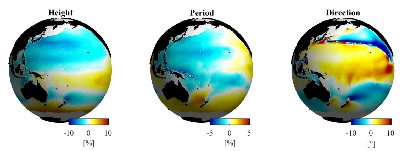
Projection of future coastal climate
The 5th IPCC report (IPCC, 2013) lists sea level rise and ocean wave characteristics change due to global warming, an important issue for human activity near the coastal zone. This sea-level rise has been observed at a rate of 3.6 mm/yr from 2006 to 2015 (1.4 mm/yr from 1901 to 1990). The rise in sea level has significantly accelerated during the last ten years. However, sea level rise is a static consequence of climate change - ocean waves and storm surges are dynamic components. These dynamic phenomena must be considered for coastal disaster prevention and reduction if future extreme weather events become stronger than those in the present climate. Furthermore, the future reliability of coastal structures and coastal beaches depends on ocean wave climate changes. Our research group predicts ocean wave climate under the climate change scenario.
Reference
- Odériz I., I.J. Losada, R. Silva, N. Mori (2024) Global assessment of long-term hazard variability in coastal urban areas and ecosystems, Environmental Research Letters, 19, 114040
https://doi.org/10.1088/1748-9326/ad7b5b - Mori, N., T. Shimura (2020) Climate change and coastal disasters, Hydrolink (Magazine), Number 1, pp.20-22.
- Morim, J. et al. (2019) Robustness and uncertainties in global multivariate wind-wave climate projections, Nature Climate Change, 10.1038/s41558-019-0542-5
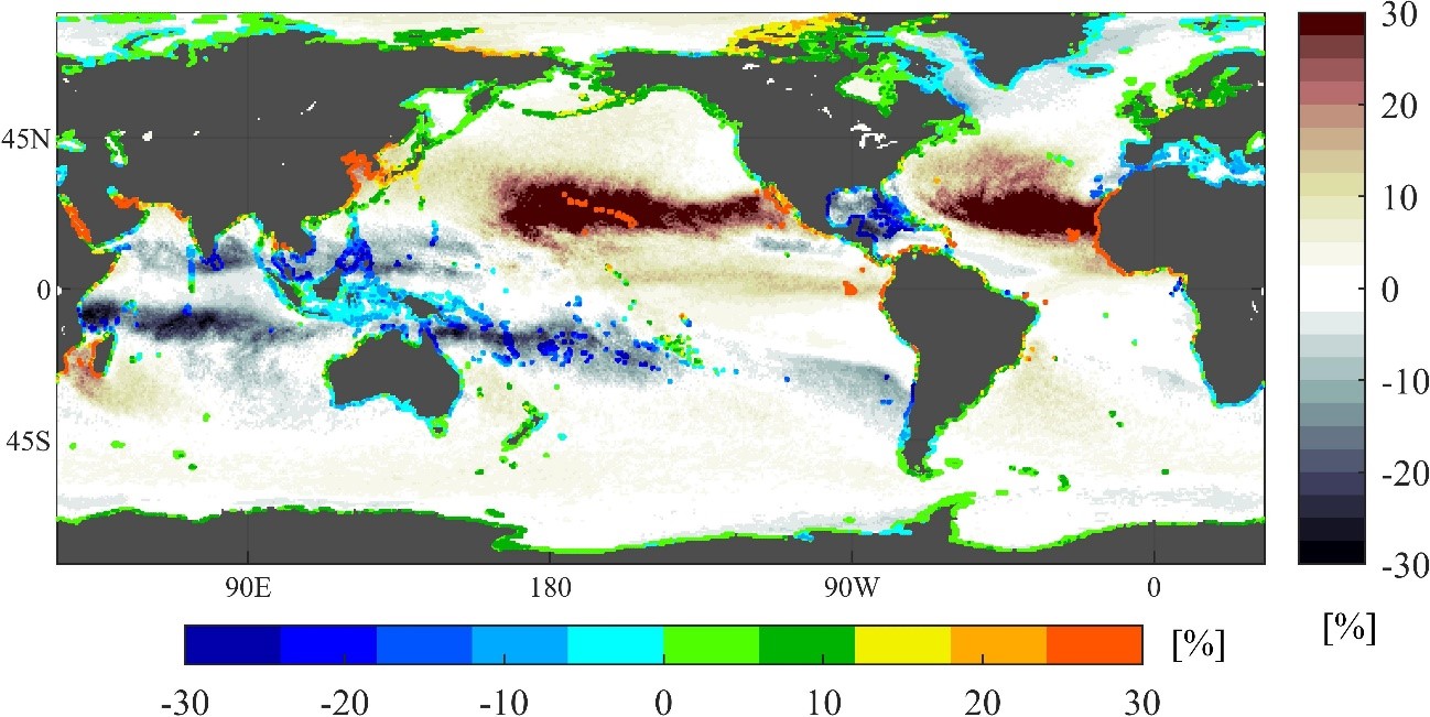
Coastal adaptation for changing climate
Both TC intensity and track changes are linked to future changes in extreme storm surges and wave climates in middle latitudes. This brief review summarizes historical and future long-term changes in extreme water levels, the contribution of increased storm surges, and wave height by the monitoring data and climate projections.
An increase in extreme water levels of 1 m or more can occur at the end of this century, which is the sum of the SLR plus the change in storm surge deviation compared to the current design water level of disaster prevention facilities in coastal areas. Such a future could appear in 70–80 years. As ESL and TWL increase with climate change, the timing and extent of adaptation measures (new or raised levees) will depend on changes in water levels and local conditions. Hardware development requires a budget and construction period, which may sometimes take 10 years or even longer. We need to reduce the vulnerability of coastal areas in a timely and wise manner by looking at climate projections and realistic plans.
References
- Mori, N., T. Shimura (2023) Tropical cyclone-induced coastal sea level projection and the adaptation to a changing climate, Cambridge Prisms: Coastal Futures, Vol.1, e4
https://doi.org/10.1017/cft.2022.6
Tsunami Hazards
At 14:46 local time on March 11, 2011, a magnitude 9.0 earthquake occurred off the coast of northeast Japan. This earthquake generated a tsunami that struck Japan and various locations around the Pacific Ocean. We have restarted tsunami research from a new perspective based on the knowledge gained from the Tohoku Earthquake Tsunami. We expect to apply the outcome of this project to the assumed Nankai-Tonankai earthquake tsunami, which is highly expected to occur within 50 years in the eastern part of Japan.
The 2011 Tohoku Earthquake Tsunami
Joint research groups conducted a tsunami survey along a 2000 km stretch of the Japanese coast with the participation of researchers from throughout Japan. More than 5,300 locations have been surveyed, generating the largest tsunami survey dataset in the world. We are currently analyzing the dataset to understand this phenomenon from scientific and engineering points of view.
References
The 2011 Tohoku Earthquake Tsunami Joint Survey Group (2011) Nationwide field survey of the 2011 off the Pacific coast of Tohoku Earthquake Tsunami, Journal of Japan Society of Civil Engineers, Series B-2, Vol.67, No.1 pp.63-66.
Mori, N., T. Takahashi and The 2011 Tohoku Earthquake Tsunami Joint Survey Group (2012) Nationwide post event survey of the 2011 Tohoku Earthquake Tsunami, Coastal Engineering Journal, Vol.54, Issue 1, pp.1-27.

Numerical Modeling of Inland/Nearshore Tsunami
The tsunami had been modeled by the shallow water equation based on the long-wave assumption for an irrotational fluid. The survey and analysis of the Tohoku Earthquake Tsunami gave us unexpected tsunami behavior that lies outside of conventional tsunami modeling. We have started to develop new numerical models for tsunami propagation and inundation based on adaptive mesh refinement, quasi-3D models, and full 3D models, respectively.

Probabilistic Tsunami Hazard Modeling
The 2004 Indian Ocean Tsunami renewed global interest in tsunami hazard assessment, and the 2011 Tohoku Earthquake Tsunami has accelerated the progress in tsunami hazard research. An accurate assessment of tsunami hazards and quantification of the uncertainty associated with the assessment are essential to mitigate and control disaster risk exposures effectively from a tsunami risk management perspective.
One of the major challenges for tsunami impact assessment is to predict the earthquake source characteristics of future tsunamigenic events (e.g., location, magnitude, and geometric slip distribution), and then to quantify the uncertainty associated with the variability in earthquake rupture (tsunami generation), tsunami propagation, and tsunami inundation processes. In particular, tsunami generation is influenced by the complex and nonlinear interaction of earthquake generation properties, while tsunami propagation, affected by changes in sea bathymetry, is generally considered a ‘solved’ problem.
Reference
Mori, N., K. Goda and D.T. Cox, Recent process in Probabilistic Tsunami Hazard Analysis (PTHA) for mega thrust subduction earthquakes, In Reconstruction and Restoration after the 2011 Japan Earthquake and Tsunami: Insights and Assessment after 5 years, Springer, in press.
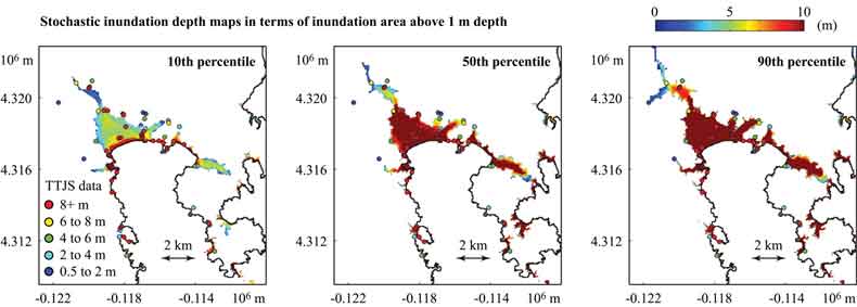
Probabilistic tsunami inundation mapping by PTHA
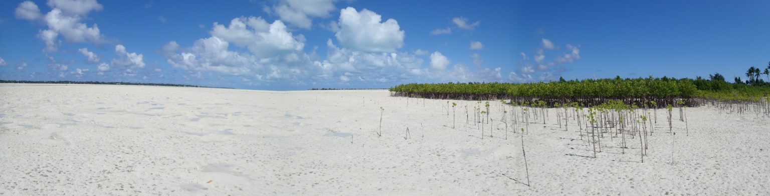
Green Infrastructure for Coastal Eco Disaster Risk Reduction (Eco-DRR)
Climate change is expected to increase coastal hazards. Tropical cyclones (typhoons) in the western North Pacific cause severe damage, such as Typhoon Haiyan's landing in the Philippines in 2013. The role of mangroves in coastal damage reduction was observed in the 2004 Indian Ocean Tsunami, and “green infrastructure” has been implemented in southern countries.
We study an integrated system of coastal hazard reduction by green infrastructure (especially mangroves). The development of downscaling of typhoons, waves and surges, and fluid force reduction by green infrastructure is a challenging topic. We also study a combination of green and gray infrastructure considering life cyclone cost (LCC) targeting the Philippines.
Reference
- Chang. C.W., N. Mori (2019) Engineering Functional Evaluation of Mangrove Forests for Coastal Disaster Reduction, Hydrolink (Magazine), Number 4, pp.110-113.
Basic Studies
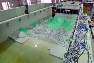
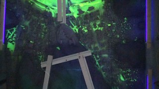
Tsunami Modeling
 |  |
Storm Surge Modeling
Storm surge is a transient abnormal rise of sea level induced by two factors: suction force due to air pressure depression and drift shear force due to strong wind speeds. Storm surges can lead to severe inundation and damage to coastal areas, and the accompanying storm waves can lead to further damage to storm barriers and amplified inundation disasters. Our research group develops multi-physics model of coupled 2D and 3D storm surge models and wave models to predict coastal disasters.

Extreme/Freak Wave Prediction
Freak waves, sometimes called Rogue waves, have a massive impact on ocean structures, oil platforms, ships, etc. However, the occurrence mechanisms and probability are still unknown. This research project started in 1990 and is still underway.


Ocean Wave Measurements
Extreme waves, such as freak waves, are unsteady and inhomogeneous phenomena. It isn't easy to measure such phenomena by in-situ measurements. Therefore, a new measurement technique for spatial wave profiles is expected to be developed. We are developing a new X-Band Radar type for freak wave measurements.

International Projects
The Coordinated Ocean Wave CLImate Project (COWCLIP)
The Coordinated Ocean Wave Climate Project (COWCLIP) is an international collaborative research project, being a component of the work-plan for the Expert Team on Waves, Coastal Hazards and Marine Emergency Response (ET-WCHMER) in World Meteorological Organisaiton (WMO)
Reference
- The Coordinated Ocean Wave Climate Project (COWCLIP) in CSIRO
- The Coordinated Ocean Wave Climate Project (COWCLIP) in WMO
SurgeMIP
Storm surges and extreme sea levels: Review, establishment of model intercomparison and coordination of surge climate projection efforts (SurgeMIP). SurgeMIP is an international collaborative research project, being a component of the work-plan for the Expert Team on Waves, Coastal Hazards and Marine Emergency Response (ET-WCHMER) in World Meteorological Organization (WMO)
Reference